-
 The Sarasota County Commission on Wednesday approved a $91.8 million budget amendment to fund hurricane recovery projects, a stark reminder that efforts to return the area to a sense of normalcy after a rash of major storms remains a work in progress.
 -
 Local experts say that with an increase in tropical disturbances, and as the area progresses into a new hurricane season every year, mangroves have little time to recover, and therefore, lack strength to guard our coastlines from inclement weather.
 -
 National Weather Service meteorologists across the state of Florida are teaming-up before the peak of hurricane season to review recommended tropical readiness, preparedness, response and recovery actions.
 -
 A “below-normal” year for storms could further a positive trend for Florida's insurance market, industry experts contend. But because of Florida’s location between the Atlantic and Gulf, homeowners will always be at risk, which will temper any potential reductions to premiums.
 -
 The National Hurricane Center released its first daily outlook for the Atlantic, Caribbean and Gulf on Friday which showed no tropical activity was expected over the next week.
 -
 On the verge of the 2026 hurricane season emergency management workers from Florida and well beyond are in Palm Beach County this week for the annual Governor's Hurricane Conference. Attendees got to hear some first-hand experience from Lee County.
 -
 AAA and IBHS Insurance experts offer some guidance to help residents prepare.
 -
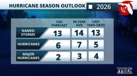 Colorado State University’s 2026 Atlantic hurricane season outlook calls for below-normal activity across the Atlantic basin due to a likely transition into an El Niño.
 -
 A free Community Conversation on Hurricane Preparedness event is plannedfrom 9a.m.to 1 p.m. on Saturday, April 11 at Riverview High School inSarasota.
 -
 Pre-season predictions on the number of hurricanes that will make landfall in Florida this year are certain to differ among the leading tropical storm forecasters, figures that get refined and reissued as the season unfolds. One thing that will now be a constant is the National Hurricane Center’s addition of more watches and warnings on its familiar “cone of uncertainty,” which has been used for more than two decades. It's a teardrop-shaped offering of the most educated guesses available about the direction of a hurricane over its next few days.

© 2026 WGCU News
PBS and NPR for Southwest Florida
Play Live Radio
Next Up:
0:00
0:00
Available On Air Stations


