

Temperatures will remain very cold across Florida today. While very light snow was reported across parts of the state on Saturday, including cities like Tallahassee and Jacksonville, a few flurries were also reported in Gainesville.
A few more flurries were spotted by drivers in the Tampa Bay area, specifically in the Wesley Chapel area located just northeast of Tampa Bay. There were no snow accumulations. Nonetheless, it was an incredible experience for Florida natives.
The cold continues Sunday night and into the beginning of the week.
Sunday night will feature many freeze warnings in effect across the Sunshine State. Where freeze warnings are not in effect—mainly across the metro areas of Miami-Dade, Broward, and western Monroe County—a cold weather advisory is in place. This means temperatures will remain very cold and feel even colder due to wind chill. These warnings are in effect through at least Monday.
❄️SNOW IN SOUTHWEST FLORIDA❄️: Did you see it? I had nothing at my place in the Cape, but check out the flurries in Lehigh Acres early this morning.
— Trent Aric (@TrentAricTV) February 1, 2026
🎥 Victoria Paschke#snow #florida #winter pic.twitter.com/GmnM4b8S4y
An important factor about tonight's cold is that it will be more prolonged, with temperatures well below freezing. This is incredibly impactful for Florida crops, as this marks the second day in a row of freezing temperatures that could cause significant damage. Temperatures across inland Florida will drop into the mid-20s. The lack of wind tonight will make conditions especially favorable for freezing, probably impacting more the crops.
Across the Tampa Bay area, low temperatures will drop into the low 30s, with similar temperatures expected across Palm Beach County. Meanwhile, Southwest and Southeast Florida will remain closer to the mid-30s.
Our arctic plunge will continue for another night.
— NWS Miami (@NWSMiami) February 1, 2026
There is a high chance (70-90%) of dangerous feels-like temperatures below 35F tonight across all of South Florida.
There is also a medium to high (40-80%) of freezing temperatures across most of inland South Florida. https://t.co/U65RsQWCrv pic.twitter.com/oAqyDqUqts
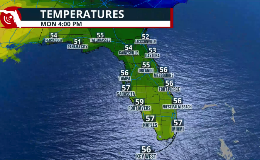
The week will start out quiet, with a high-pressure system over Florida, bringing plenty of sunshine throughout. Although temperatures will gradually increase, they are expected to remain below normal throughout the week.
Highs on Monday could be anywhere from 10 to 18 degrees below average for this time of year. Widespread 50s are expected across the Florida Peninsula, except for the Florida Keys, where low 60s may be reached. By Wednesday, temperatures will reach the 70s across the southern half of the peninsula, while the northern half remains between the upper 60s and low 70s.
Another hard freeze is expected tonight with dangerously low wind chill values. 🥶
— NWS Jacksonville (@NWSJacksonville) February 1, 2026
Keep those plants & pets inside, and limit time outdoors. pic.twitter.com/CtDweKrwjG
Another cold front is coming later this week.
Another cold front will push through Florida between Wednesday night and Thursday morning. Although this front is not expected to bring Arctic temperatures like those experienced this weekend and early this week, another noticeable drop in temperatures is expected. Highs on Thursday will struggle to rise out of the mid-50s across the northern half of the peninsula. Central Florida will see highs in the 60s, while South Florida reaches the 70s.


Friday morning will bring another cold start across the state, with temperatures once again falling into the 20s across the Panhandle. Temperatures will remain between the upper 30s and low 40s across Central Florida, while Southeast Florida could drop into the mid-40s.
Copyright 2026 Storm Center


