The size and scope of the wildfire that's been burning in the Big Cypress National Preserve for over a week-and-a-half took a small step back Friday with a reduction in fire area and a small increase in containment.
That being said, the numbers change was the result of better mapping. Here's how fire officials put it: "The size of the National Fire was adjusted slightly on Friday, March 6, due to more accurate mapping. The slight decrease in acreage was verified by firefighters on the ground. The fire footprint has remained essentially unchanged since Tuesday, March 3."
That better mapping placed the National Fire at 35,027 acres burned and at 67 percent contained by late Friday, according to a press briefing issued by the command structure of the wildfire. That was about 300 fewer acres and three percent more containment.
Furthermore, the press briefing statement said about Friday's activities at the fire: "Firefighters focused on isolated smoke from smoldering logs and heavy fuels within the fire perimeter. The entire perimeter was patrolled and monitored by engine crews.
"Containment increased slightly ... even with persisting hot, dry and windy conditions. The variety of vegetation types in the greater Everglades ecosystem, combined with current drought and dry weather conditions leads to slow progress on containment."
The newest fire information said that on Saturday, and for the next several days, firefighters will continue patrolling and monitoring the full fire perimeter and will continue to seek out and extinguish areas of heat within the fire perimeter. Aerial resources remain available to assist firefighters on the ground if needed. Crews will respond if fire activity intensifies as warmer and drier weather moves into the area.
Mowing of roadside vegetation on Turner River Road is ongoing to provide more defensible space.
A National Park Service area closure for a portion of Big Cypress National Preserve remains in effect.
A new amendment to the closure went into effect Wednesday that reduced the size of the closure area, reopening all areas east of Turner River Road (CR-839) to public use.
The current closure area includes the area south of I-75, east of SR-29, north of US-41 and west of Turner River Road. This closure is in place for the safety of both the public and fire personnel.
Additional closure information is available in the Alerts section of the Big Cypress National Preserve website: https://www.nps.gov/bicy/index.htm
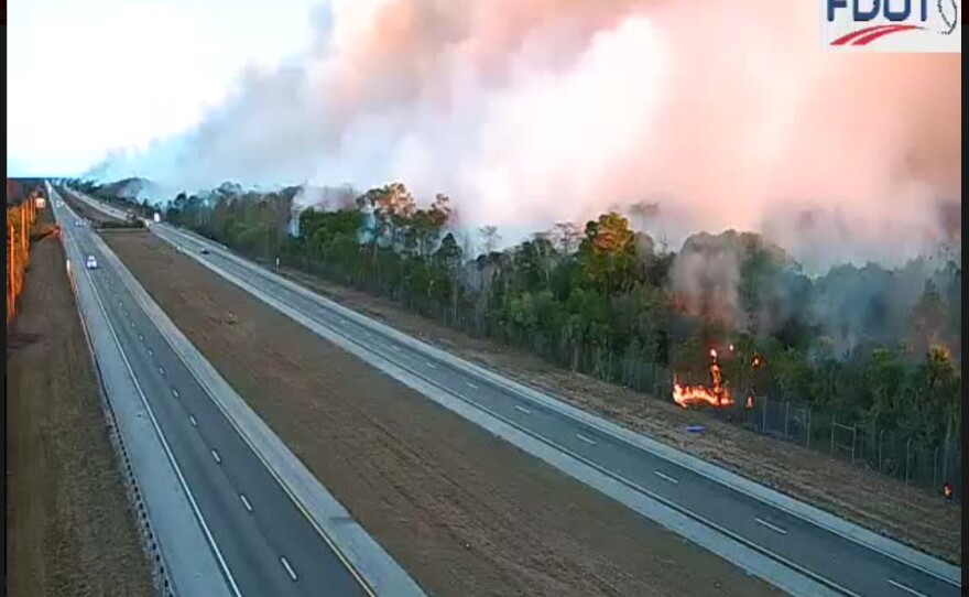
The FHP also said troopers will continue to monitor visibility conditions along the I-75 corridor and U.S. 41.
The blaze started the night of February 22 in the Big Cypress National Preserve. No cause has been determined, and an investigation into how it started is underway.


The massive blaze is feeding on heavy brush turned to kindling by past hurricanes and a string of brutal freezes this winter that killed off vegetation across the Everglades.
No structures have been damaged and no firefighters have been hurt by the fire.

For context, this National Fire has already surpassed the Sandy Fire that burned through the same area three years ago. That blaze blackened nearly 20,000 acres, shutting down U.S. 41 and blanketing the region in smoke.
Even though the Sandy Fire burned the same area, it left behind plenty of fuel.
There is also a Temporary Flight Restriction (TFR) in effect over the fire area. The public is asked not to fly any type of aircraft, including drones, near the fire area. Unauthorized drone (UAS) flights pose serious risks to the effectiveness of firefighting operations. Aerial firefighting is suspended when unauthorized UAS are in the area, allowing wildfires to grow larger.
Troopers continue to monitor ongoing wildfire conditions along Interstate 75 (Alligator Alley between mile markers 65–85) in Collier County.
Motorists traveling through the area are urged to use caution, reduce speed, and remain alert for changing conditions.
- DRIVE WITH LIGHTS on low beam. High beams will only be reflected off the fog and impair visibility even more. Your lights help other drivers see your vehicle, so be sure they all work. Keep your windshield and headlights clean, to reduce the glare and increase visibility.
- SLOW DOWN and watch your speedometer before you enter a patch of fog.
- WATCH OUT for slow-moving or stopped vehicles. Open you window a little and listen for traffic you cannot see.
- REDUCE THE DISTRACTIONS in your vehicle. Turn off the radio and keep your cell phone down. Your full attention is required.
- USE WIPERS AND DEFROSTERS for maximum visibility. Sometimes it is difficult to determine if poor visibility is due to fog or moisture on the windshield.
- USE THE RIGHT EDGE of the road or painted road markings as a guide.
- BE PATIENT avoid passing and/or changing lanes.
- SIGNAL TURNS well in advance and brake early as you approach a stop.
WGCU is your trusted source for news and information in Southwest Florida. We are a nonprofit public service, and your support is more critical than ever. Keep public media strong and donate now. Thank you.