-
 La Niña conditions are expected to start influencing Florida's weather. Historically, La Niña Novembers have featured below-average rainfall and only brief cold snaps.
 -
 Showers and thunderstorms during the first half of the workweek could put down around an inch of precipitation, with heavier accumulations expected in the Florida Panhandle.
 -
 Melissa went from 75 mph to 140 mph in less than 24 hours. Jamaica braces for direct impact.
 -
 Melissa to crawl over the Caribbean. Heavy rains and dangerous flooding in Jamaica, Haiti, and the Dominican Republic.
 -
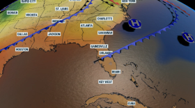 Humidity levels will continue to fluctuate as several fronts make their way fhrough Florida. Another push of dry air comes midweek.
 -
 Hurricane Kate, which struck the Florida Panhandle on November 21, 1985, remains the latest hurricane on record to make landfall in the continental United States.
 -
 There is a high chance of a tropical wave developing over the next 7 days as it moves through the Caribbean. It does not currently pose a threat to Florida.
 -
 Forecasters are monitoring two areas of disturbed weather in the Atlantic. The tropical wave that is in the central Atlantic has the best chance of developing once it enters the Caribbean Sea.
 -
 Is this it for Florida's rainy season? There are still areas dealing with a worsening drought, which could mean bad news for the coming dry months and wildfires.
 -
 The recently declared La Niña is expected to persist through into the winter. The pattern often fuels increased tornadoes and severe weather across parts of the county, except in Florida.

© 2026 WGCU News
PBS and NPR for Southwest Florida
Play Live Radio
Next Up:
0:00
0:00
Available On Air Stations


